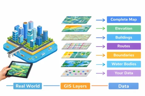
Advanced GIS mapping via drones combines cutting-edge Unmanned Aerial Vehicles (UAVs) with Geographic Information System (GIS) technology. This is used to create highly accurate, detailed maps and 3D models faster and more cost-effectively than traditional surveying methods.
The reality is that drone technology has fundamentally changed the mapping landscape. This powerful combination is one reason advanced mapping services have become a major opportunity for pilots learning how to make money with drones across industries such as construction, agriculture, environmental monitoring, and urban planning.
At Drone Launch Academy, we’ve trained over 58,000 UAV pilots and seen firsthand how this technology streamlines what used to take weeks of fieldwork into just hours of flight time. Understanding the fundamentals of drone mapping and modeling is crucial for any professional looking to leverage this game-changing technology.
Key Takeaways
- Advanced GIS mapping with drones delivers survey-grade accuracy at 70-90% lower cost than traditional methods while dramatically reducing project timelines
- RTK and PPK positioning systems enable centimeter-level precision, making drones viable for professional surveying applications
- Modern software platforms automate complex photogrammetry workflows, allowing professionals to focus on analysis rather than technical processing
- Integration with ArcGIS systems creates seamless workflows from data collection through final deliverable production
- Drone Launch Academy offers an Advanced Drone Mapping and Modeling Program that teaches pilots and professionals how to capture, process, and analyze high-accuracy aerial data using industry-standard drone mapping and GIS workflows for real-world applications.
Advanced GIS Mapping Via Drones
Drones have completely transformed traditional mapping workflows by providing unprecedented access to aerial perspectives at a fraction of the cost of manned aircraft or satellite imagery.
It enables:
- Speed Enhancement: What used to take survey teams weeks to map on foot now takes hours with drones. A single flight can cover hundreds of acres in one session.
- Cost Reduction: Traditional aerial surveys using helicopters or planes cost thousands per flight hour. Drone operations typically run $200-500 per day, including operator fees.
- Safety Improvements: Dangerous terrain, steep slopes, and hazardous areas become accessible without putting human surveyors at risk.
- Data Quality: Modern drones capture imagery with centimeter-level accuracy, often exceeding the precision of traditional methods.
Understanding Drone Integration in Surveying Practices
GIS drones seamlessly integrate into existing surveying workflows through established protocols and software systems. The integration process typically follows these steps:
- Flight Planning: Software like DroneDeploy or Pix4D creates automated flight paths based on survey requirements
- Data Capture: Drones collect overlapping images with 70-80% forward and side overlap
- Processing: Specialized software converts raw imagery into usable GIS formats
- Analysis: Results integrate directly into existing GIS platforms like ArcGIS or QGIS

Key integration benefits include:
- Seamless Workflow: Direct export to CAD and GIS software formats
- Real-time Processing: Some systems provide preliminary results during flight operations
- Quality Control: Built-in accuracy checks ensure data meets surveying standards
- Scalability: Systems handle projects from single acres to thousands of square miles
Key Benefits and Efficiency in Data Collection
GIS drone mapping delivers measurable advantages that directly impact project timelines and budgets.
Accuracy Improvements:
- Sub-centimeter precision with RTK/PPK systems
- Consistent data quality across entire survey areas
- Reduced human error through automated flight patterns
The best drones for GIS mapping dramatically reduce data collection timeframes:
| Traditional Method | Traditional Timeline | Drone Method Timeline | Time Savings |
| Ground Survey (100 acres) | 2–3 weeks (fieldwork + processing) | 1–2 days | 85–90% |
| Manned Aircraft Survey | 3–5 days (flight scheduling, capture, processing) | 4–6 hours | 70–80% |
| Satellite Imagery Analysis | 1–2 weeks (tasking, acquisition, analysis) | Same day | 80–95% |
Data Processing Efficiency:
- Automated workflows handle image stitching and georeferencing
- Cloud processing eliminates the need for powerful local computers
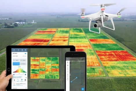
- Multi-spectral data reveals information invisible to human eyes
- Volume calculations provide accurate cut-and-fill measurements
This efficiency particularly benefits drone applications in agriculture, where timing is critical for crop monitoring and yield optimization.
Turning Aerial Imagery into 3D Maps
LiDAR mapping drone technology and photogrammetry workflows collect accurate spatial data that GIS systems use to analyze, visualize, and manage geographic information. These workflows transform flat imagery into detailed three-dimensional representations.
Photogrammetry Process:
- Image Acquisition: Overlapping photos from multiple angles
- Feature Matching: Software identifies common points between images
- Bundle Adjustment: Mathematical optimization creates accurate 3D positions
- Mesh Generation: Point clouds become textured 3D surfaces
3D point cloud generation produces millions of precisely positioned points that represent ground features. Each point contains coordinates, color information, intensity data, and feature classification.
Output Products:
- Digital Surface Models (DSM): Show all visible surfaces, including vegetation and structures
- Digital Terrain Models (DTM): Display bare earth after vegetation removal
- Contour maps: Traditional elevation representations
- 3D meshes: Textured models for visualization and analysis
Advanced GIS Tools and Visualization
Advanced GIS mapping using drones reaches its full potential when combined with modern visualization and analysis tools.
Visualization Enhancements:
- Interactive 3D models allow stakeholders to explore projects virtually
- Time-lapse animations show project progress or environmental changes
- Cross-sectional analysis reveals subsurface conditions and volumes
Analysis Capabilities:
- Slope analysis identifies unstable areas and drainage patterns
- Viewshed analysis determines visibility from specific locations
- Change detection quantifies differences between survey dates
Ground control points ensure survey accuracy by providing known reference positions. Modern workflows require fewer GCPs thanks to RTK/PPK technology, but they remain essential for accuracy verification and legal documentation.
RTK vs PPK: Choosing Your Positioning Method
RTK drone mapping and PPK drone mapping represent two approaches to achieving survey-grade accuracy:
RTK (Real-Time Kinematic) Benefits:
- Immediate results with centimeter accuracy during flight
- Real-time quality control allows mission adjustments
- Simplified workflow requires less post-processing
RTK Limitations:
- Radio range restrictions limit flight distance from the base station
- Communication requirements need reliable data links
PPK (Post-Processed Kinematic) Advantages:
- No range limitations for flight operations
- Better accuracy potential through extended processing time
- Multiple reference options can use various base station data
PPK Limitations:
- Requires additional post-processing time before results are available
- Errors may not be identified until after processing is completed
| Factor | RTK | PPK |
| Accuracy | ± 2–5 cm | ± 1–3 cm |
| Flight Range | Limited | Unlimited |
| Results Timeline | Immediate | 1–2 hours |
Orthomosaic Mapping and Professional Software
Orthomosaic map creation is one of the most common and valuable outputs of drone mapping. These geometrically corrected images serve as accurate base maps for GIS analysis.
Quality Factors:
- Ground Sample Distance (GSD): Determines pixel size and detail level
- Overlap Percentage: Higher overlap improves accuracy but increases processing time
- Flight Altitude: Lower flights provide better resolution but cover less area
Professional-Grade Solutions:
- Pix4D: Industry standard with advanced photogrammetry algorithms
- Agisoft Metashape: Powerful processing engine favored by surveying professionals
- Trimble Inpho: Enterprise-level solution with extensive GIS integration
Cloud-Based Platforms:
- DroneDeploy: User-friendly interface with automated processing workflows
- Maps Made Easy: Cost-effective solution for smaller projects
- Propeller Aero: Construction-focused with progress tracking features

ArcGIS Integration for Advanced Analysis
ArcGIS Drone2Map Features:
- Direct Processing: Converts raw drone imagery into GIS-ready products
- Quality Control: Built-in accuracy assessment and reporting tools
- Automated Workflows: Streamlined processing from images to analysis
Analysis Capabilities:
- Change Detection: Compare surveys across time periods
- Volume Calculations: Accurate measurements for construction
- 3D Analysis: Slope, aspect, and visibility studies
Visualization Options:
- Web Mapping: Share results through ArcGIS Online platforms
- Dashboard Creation: Real-time monitoring and reporting interfaces
- Mobile Access: Field verification using ArcGIS mobile applications
Getting Started with Professional Drone Mapping
Professional drone mapping requires proper training, equipment selection, and workflow development:
Training Requirements:
- Part 107 Certification: Required for commercial drone operations
- Software Proficiency: Training on chosen mapping platforms
- GIS Knowledge: Understanding of coordinate systems and spatial data
Equipment Considerations:
- Drone Selection: Match capabilities to project requirements
- Camera Systems: RGB, multispectral, or LiDAR sensors
- Ground Equipment: Base stations for RTK/PPK workflows
Workflow Development:
- Project Planning: Define accuracy requirements and deliverables
- Quality Control: Establish verification procedures and standards
- Data Management: Organize files and maintain project archives
Advance Your Drone Career With Industry-Ready Mapping Skills
Ready to take your mapping capabilities to the next level? Drone Launch Academy’s Advanced Drone Mapping and Modeling Program (ADMM) provides comprehensive training on professional workflows, software mastery, and business development strategies.
We help drone pilots move beyond basic flying into high-value drone mapping and modeling work used in construction, engineering, and surveying.
Our ADMM program teaches you how to confidently capture, process, and deliver survey-grade aerial data that clients actually pay for.
| Category | Details |
| What You’ll Learn | ✔ Geodesy fundamentals and coordinate systems
✔ GNSS positioning and RTK/PPK accuracy workflows ✔ Professional drone photogrammetry processing ✔ Advanced 3D modeling and digital twin creation ✔ Industry-standard mapping and reporting workflows |
| What You’ll Be Able to Create | ✔ Orthomosaic maps
✔ Contour and topographic models ✔ Stockpile volume reports ✔ Construction progress data ✔ High-precision 3D models |
| Why Pilots Choose Drone Launch Academy | ✔ Industry-recognized certification
✔ Expert-led, real-world training ✔ Step-by-step learning path ✔ Lifetime access to course materials ✔ Skills aligned with high-paying mapping contracts |
Whether you want to grow your drone business, land larger projects, or specialize in advanced GIS and mapping workflows, this program gives you the technical skills and confidence to stand out.
Start building in-demand drone mapping expertise today.