Last Updated: June 3, 2026
Drone mapping is one of the best next skills for drone pilots who want to move beyond basic photos and videos. Instead of simply capturing a nice aerial shot, you can create maps, 3D models, measurements, and reports that help clients understand a property, project, field, roof, stockpile, or construction site.
For beginners, that can sound intimidating. The good news is that you don’t need to become a land surveyor overnight to start learning the workflow. You do need to understand the basics: how mapping works, what deliverables clients expect, what gear and software are involved, what Part 107 requires, and when to level up into more advanced accuracy workflows.
TL;DR: Drone mapping uses overlapping aerial images or video to create measurable 2D maps and 3D models. If you’re brand new, start with the fundamentals: Part 107, flight planning, photogrammetry basics, clean data capture, and simple deliverables. Drone Launch Academy’s Drone Mapping & Modeling Course Fundamentals is the beginner path, while the Advanced Drone Mapping & Modeling Certification is the next step for working pilots who want survey, construction, GNSS, RTK/PPK, GCP, and professional deliverable training.[1] [2]
Key Takeaways
| Key point | What beginners should know |
|---|---|
| Drone mapping is data work. | You’re creating usable maps and models, not just attractive aerial images. |
| Start simple. | Beginners should first learn flight planning, overlap, image quality, software processing, and client deliverables. |
| Part 107 matters. | If you fly drone mapping missions for business in the United States, you generally need to operate under FAA Part 107.[3] |
| Accuracy has levels. | A practice map is different from a professional deliverable using GNSS, RTK/PPK, GCPs, and survey-control workflows. |
| Drone Launch Academy has a course path. | Start with Mapping & Modeling Fundamentals, then move to the Advanced Drone Mapping & Modeling Certification when you’re ready for higher-value work.[1] [2] |
What Is Drone Mapping?
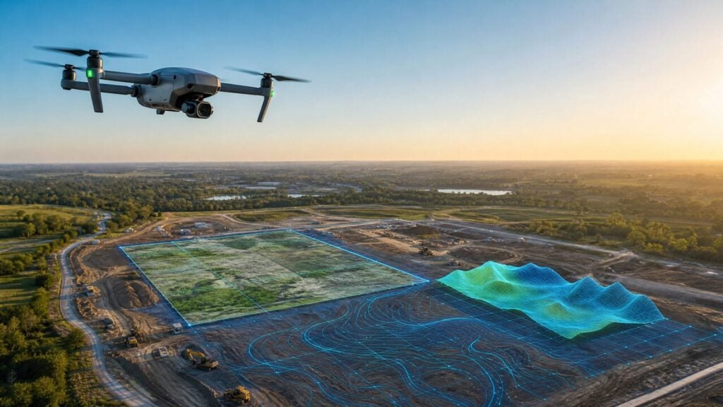
Drone mapping is the process of flying a drone over an area, capturing overlapping images or video, and processing that data into a map, model, or measurement-based deliverable. Common outputs include orthomosaic maps, 3D models, contour maps, cut-and-fill reports, stockpile volumes, and site-progress visuals.
The easiest way to understand it is this: a drone photo shows what a site looks like, while a drone map helps someone measure, compare, document, or plan around that site. That is why mapping is useful in construction, real estate development, agriculture, roofing, solar, infrastructure inspection, and land-management work.
Most beginner mapping is built around photogrammetry, which means software compares many overlapping images and reconstructs the area as a 2D or 3D output. As you advance, you may also learn workflows involving GNSS, RTK, PPK, ground control points, and survey-control concepts.
How Does Drone Mapping Work?
Drone mapping usually follows a simple workflow: plan the mission, fly the site, capture clean overlapping data, process the images or video, then deliver a map or model. The quality of the final result depends heavily on the quality of the flight plan and the data captured in the field.
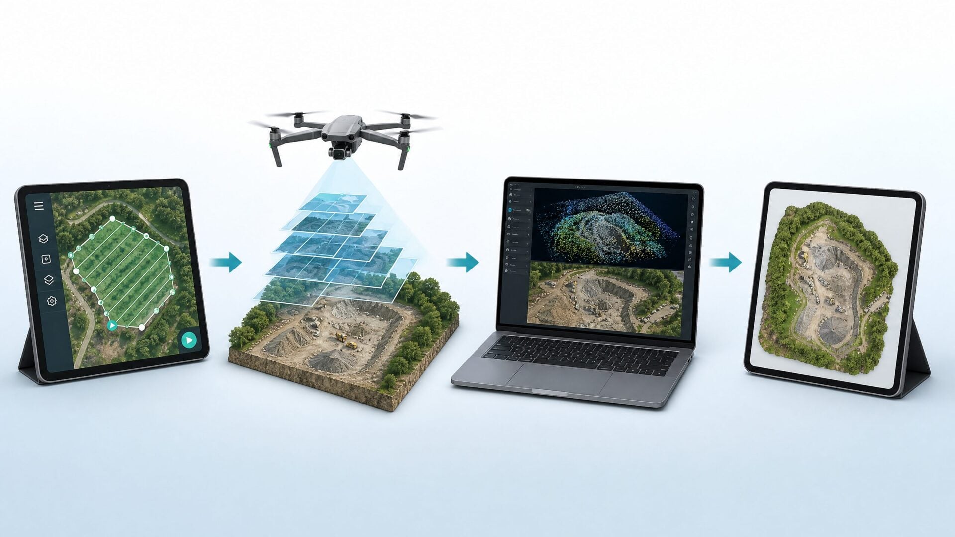
| Step | What happens | Beginner focus |
|---|---|---|
| Plan | Decide the area, altitude, overlap, flight path, airspace, and desired deliverable. | Know what you’re trying to create before takeoff. |
| Fly | Capture consistent images or video across the site. | Avoid blur, gaps, poor lighting, and unsafe flight conditions. |
| Process | Use mapping software to turn raw data into a map or model. | Learn what good data looks like before selling paid work. |
| Deliver | Share an orthomosaic, 3D model, measurements, or report. | Sell a clear result, not “some drone footage.” |
This is where beginners often make their first mistake. They buy a drone, fly a site, and hope software will make everything work. Better mapping starts before takeoff. You need to know the deliverable, the required level of detail, and whether the job is just visual documentation or something more accuracy-sensitive.
What Can Beginners Use Drone Mapping For?
Beginners can use drone mapping to build practical skills and sample deliverables for small sites, practice areas, roof or property documentation, construction progress visuals, basic 3D models, and portfolio examples. The best early projects are low-risk practice missions where no client is relying on the data for legal or engineering decisions.
For example, a beginner might practice mapping an open field, a small construction area with permission, a family property, or a non-sensitive outdoor site. The goal is to learn how flight settings affect the final output. Once you can consistently create clean maps and explain what they do, you can start thinking about a niche.
Good beginner-friendly niches include real estate development visuals, roof and solar documentation support, construction progress photos with map deliverables, and simple property overviews. More advanced niches, such as survey support, engineering workflows, and high-accuracy construction deliverables, require more training and stronger accuracy controls.
Do You Need a Part 107 License for Drone Mapping?
If you fly drone mapping missions for work, business, client deliverables, or any commercial purpose in the United States, you generally need to operate under FAA Part 107. The FAA says pilots using drones under 55 pounds for work or business can fly by following Part 107 guidelines.[3]
The FAA process includes learning the rules, passing the Unmanned Aircraft General knowledge test, applying for a Remote Pilot Certificate, and registering the drone.[3] You may also need airspace authorization, Remote ID compliance, permission from the property owner or site manager, and a safe operating plan.
This is why Drone Launch Academy usually recommends building the foundation first. If you don’t yet have your Part 107 certificate, start there. Mapping is a commercial skill, and clients expect you to operate legally and professionally.
Drone Mapping vs. Drone Surveying: What’s the Difference?
Drone mapping and drone surveying can overlap, but they are not automatically the same thing. Drone pilots can learn to capture aerial data and create useful maps and models, while licensed land surveying involves legal responsibilities that may require a licensed surveyor depending on the state and project scope.
For beginners, this distinction is important. You can learn how to create aerial maps and models without claiming to provide legal boundary surveys or certified survey-grade deliverables. If a project involves boundary lines, legal property records, certified topographic data, or engineering decisions, you should work with the appropriate licensed professionals.
A good beginner phrase is “mapping and modeling deliverables,” not “I’m a surveyor.” As you advance, Drone Launch Academy’s advanced program can help you understand the professional workflows used around surveyors, engineers, and construction teams, including GNSS, RTK/PPK, and ground control point concepts.[2]
What Equipment Do You Need to Start Drone Mapping?
Beginners can start learning drone mapping with a quality camera drone, extra batteries, a controller or tablet, basic mapping software, and enough open practice space to fly safely. Paid professional work may require better cameras, mechanical shutters, RTK/PPK capability, ground control points, insurance, and more advanced processing tools.
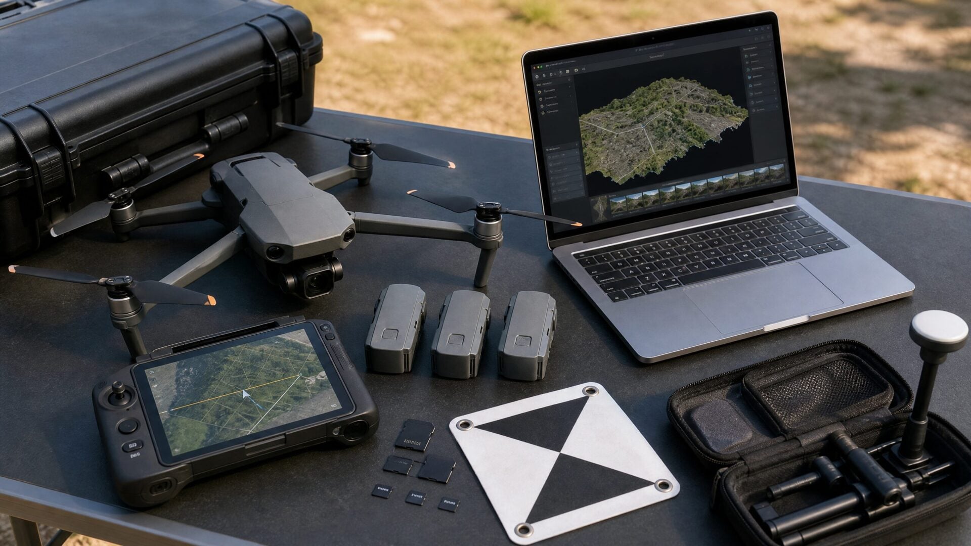
| Need | Beginner level | Advanced level |
|---|---|---|
| Drone | Quality camera drone for practice and basic maps | Mapping-focused drone with better positioning and camera features |
| Camera | Sharp RGB photos with consistent settings | Mechanical shutter, larger sensor, or specialized payloads |
| Positioning | Standard drone GPS for learning | GNSS, RTK/PPK, and ground control workflows |
| Software | Beginner-friendly mapping or modeling workflow | Professional processing, QA, reporting, and export workflows |
| Training | Fundamentals of maps, models, and deliverables | Survey, engineering, construction, and high-accuracy workflows |
The key is not to overbuy too early. If you’re still learning what overlap means, how image blur affects processing, or what an orthomosaic is, start with fundamentals. Upgrade gear when your target deliverables demand it.
What Course Should Beginners Take First?
Beginners should start with Drone Launch Academy’s Drone Mapping & Modeling Course Fundamentals because it is designed around learning how to use drones to create detailed and accurate maps and models. It is the right first step for pilots who want to understand mapping before jumping into advanced survey-style workflows.[1]
The course page frames a real problem many pilots feel: basic drone services can feel saturated, and pilots want a way to provide more value. In the fundamentals course, David Young and Rut teach what students need to know to start creating aerial maps and models for clients. Rut’s background is especially relevant because his company, Voyager Industries, uses drone mapping and modeling to help energy, agriculture, and infrastructure clients get the data they need.[1]
If you’re new to mapping, this is the course to plug into first:
Beginner next step: Learn the fundamentals in Drone Launch Academy’s Drone Mapping & Modeling Course Fundamentals.
When Should You Move to the Advanced Drone Mapping Course?
Move to Drone Launch Academy’s Advanced Drone Mapping & Modeling Certification when you already understand the basics and want to pursue higher-value mapping work for survey, construction, engineering, infrastructure, or company drone programs. It is built for working drone pilots who want industry-ready skills.[2]
The advanced program is a complete 5-course path that includes geodesy, GNSS, RTK/PPK, GCP workflows, advanced 3D modeling, and professional deliverables like contour maps, cut-and-fill reports, and stockpile volumes.[2] It is also positioned for drone service providers, companies with drone programs, and surveying, engineering, and construction firms that want to integrate drones into their workflows.[2]
| If you are… | Start here |
|---|---|
| Brand new to maps and models | Drone Mapping & Modeling Course Fundamentals |
| Comfortable with basics and ready for higher-value workflows | Advanced Drone Mapping & Modeling Certification |
| A company training pilots for construction, survey, or engineering workflows | Advanced Drone Mapping & Modeling Certification |
| A pilot trying to escape low-priced photo/video work | Start with Fundamentals, then level up to Advanced |
Advanced next step: Build professional mapping credibility with Drone Launch Academy’s Advanced Drone Mapping & Modeling Certification.
How Much Does Drone Mapping Cost to Start?
The cost to start drone mapping depends on whether you are learning, building a side service, or preparing for professional mapping contracts. A beginner may only need a capable drone, training, and entry-level software, while advanced work can require specialized hardware, paid processing tools, GNSS equipment, insurance, and deeper training.
| Cost category | Beginner expectation | Advanced expectation |
|---|---|---|
| Training | Fundamentals course and Part 107 preparation | Advanced certification and specialized workflows |
| Drone | Use a capable camera drone to learn | Upgrade when accuracy or client deliverables require it |
| Software | Start with a manageable mapping workflow | Use professional processing and reporting tools |
| Accuracy tools | Usually not needed for early practice | GNSS, RTK/PPK, GCPs, and QA workflows become important |
| Business setup | Portfolio, insurance research, simple packages | Repeatable deliverables, contracts, and niche positioning |
The smartest move is to match the investment to your current stage. Don’t buy advanced equipment just because it sounds professional. Learn the workflow, understand the deliverables, and then invest in tools that support the clients you want to serve.
How Can Drone Mapping Help You Make Money?
Drone mapping can help you make money when you use it to solve a specific client problem. Clients pay for useful deliverables, such as progress documentation, site maps, 3D models, roof measurements, stockpile volumes, contour maps, or visual reports that help them make faster decisions.

The opportunity is strongest when you pick a niche. A construction client may want repeat progress mapping. A roofer may want better documentation. A land-development company may want site visuals. An agriculture client may want field insights. A company with internal drone pilots may need training so its team can collect better data.
This is also why the Drone Launch Academy course path matters. The beginner course helps pilots learn how maps and models are created. The advanced certification helps working pilots build the skills and credibility needed for higher-value mapping and modeling work.[1] [2]
How Do You Get Started with Drone Mapping?
The best way to start drone mapping is to build the foundation in order: earn Part 107, learn mapping vocabulary, practice safe flight planning, process sample data, create simple deliverables, take beginner mapping training, and only then start offering paid services with a clear scope.
| Step | Action |
|---|---|
| 1 | Get Part 107 certified if you plan to fly commercially. |
| 2 | Learn terms like orthomosaic, 3D model, GCP, RTK, PPK, contour map, and cut-and-fill. |
| 3 | Practice flight planning on low-risk sites with permission. |
| 4 | Process sample datasets and compare results. |
| 5 | Take Drone Launch Academy’s Mapping & Modeling Fundamentals course. |
| 6 | Build a small portfolio with clear beginner deliverables. |
| 7 | Move into advanced certification when you’re ready for survey, construction, and engineering workflows. |
This path keeps you from overpromising too soon. It also gives you a natural progression from beginner skills to more advanced, higher-value work.
FAQ About Drone Mapping
What is drone mapping in simple terms?
Drone mapping means flying a drone over an area, capturing overlapping images or video, and using software to turn that data into a measurable map or 3D model. It helps clients understand a site more clearly than normal photos alone.
Is drone mapping good for beginners?
Yes, as long as beginners start with practice projects and fundamentals. The first goal is learning how flight planning, image overlap, lighting, and processing affect the final map. Paid accuracy-sensitive work should come later.
Do I need Part 107 for drone mapping?
If you fly drone mapping missions for business in the United States, you generally need to operate under FAA Part 107. The FAA outlines the process for becoming a certificated Remote Pilot and registering your drone.[3]
Which Drone Launch Academy mapping course should I take first?
If you’re new to mapping, start with Drone Mapping & Modeling Course Fundamentals. If you’re already a working drone pilot and want survey, construction, engineering, GNSS, RTK/PPK, GCP, and certification training, look at the Advanced Drone Mapping & Modeling Certification.[1] [2]
Can drone mapping replace a surveyor?
No. Drone mapping can support survey-related workflows, but licensed surveying is a regulated professional service. If a project involves legal boundary work, certified survey data, or engineering decisions, involve the appropriate licensed professionals.
What deliverables can I create with drone mapping?
Depending on your skill level and software, you may create orthomosaic maps, 3D models, contour maps, cut-and-fill reports, stockpile volumes, progress maps, and visual site reports. Beginners should start with simple maps and models before promising advanced deliverables.
Is drone mapping profitable?
It can be, but only when you solve a real client problem. Mapping is more valuable when you package it for a specific niche, such as construction, roofing, agriculture, infrastructure, or company drone programs.
Final Thoughts: Start with Fundamentals, Then Level Up
Drone mapping is a practical next step for pilots who want to provide more value than basic aerial photos and videos. The beginner path is to learn Part 107, flight planning, photogrammetry basics, clean data capture, simple processing, and clear deliverables before taking on advanced client work.
If you’re just getting started, Drone Launch Academy’s Drone Mapping & Modeling Course Fundamentals is the right first step. If you’re already working as a drone pilot or training a team and want high-value mapping skills for construction, engineering, surveying support, GNSS, RTK/PPK, GCP workflows, contour maps, cut-and-fill reports, stockpile volumes, and certification, the Advanced Drone Mapping & Modeling Certification is the natural next step.[1] [2]
Start simple. Build confidence. Then level up into the work that requires deeper accuracy, stronger deliverables, and more professional credibility.
Sources
[1] Drone Launch Academy, “Drone Mapping & Modeling Course Fundamentals”
[2] Drone Launch Academy, “Advanced Drone Mapping Course & Modeling Certification”
[3] Federal Aviation Administration, “Certificated Remote Pilots including Commercial Operators”


