Last Updated: April 28, 2026
TL;DR: The Quick Guide to Drone Power Line Inspections
Drone power line inspections use unmanned aerial systems equipped with thermal and RGB cameras to monitor the condition of transmission lines, poles, and towers. These inspections typically cost $200 to $300 per mile, offering a 50% to 75% savings over traditional helicopter methods. Getting started requires an FAA Part 107 certificate, specialized thermal imaging equipment, and utility safety training.
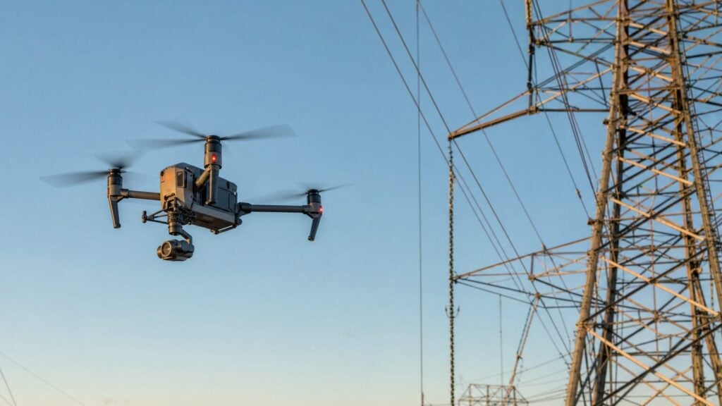
Maintaining the electrical grid is one of the most critical and dangerous jobs in the infrastructure sector. For decades, utility companies relied on ground crews hiking through rough terrain or expensive helicopter flights to inspect miles of transmission lines. Today, the industry is undergoing a massive shift. By utilizing high-resolution cameras and thermal imaging, drone pilots are taking over these dangerous inspections, making the process faster, cheaper, and significantly safer.
For commercial drone pilots, power line inspection represents a highly lucrative niche. At Drone Launch Academy, we’ve watched our students build thriving businesses by specializing in utility and infrastructure inspections. In this comprehensive guide, we will break down exactly how drone power line inspections work, what equipment you need, how much you can charge, and the steps required to get started in this high-demand field.
Key Takeaways
- Massive Cost Savings: Drone inspections typically cost $200 to $300 per mile, compared to $1,200 to $1,600 per mile for traditional helicopter inspections.
- Unmatched Safety: Drones eliminate the need for personnel to climb towers, navigate treacherous terrain, or work in close proximity to energized, high-voltage lines.
- Superior Data Quality: Modern inspection drones utilize a combination of high-resolution RGB cameras, thermal imaging, and LiDAR to detect faults that are invisible to the naked eye.
- High Income Potential: Experienced drone pilots can charge $150 to $350 per hour, or $500 to $2,000 for detailed structural inspections of individual transmission towers.
- Strict Requirements: Success in this field requires an FAA Part 107 certificate, specialized utility safety training, and enterprise-grade drones with electromagnetic interference (EMI) resistance.
What Is a Drone Power Line Inspection?
A drone power line inspection is an aerial survey that uses unmanned aerial systems (UAS) equipped with visual, thermal, and LiDAR sensors to monitor the condition of electrical infrastructure. This includes inspecting transmission lines, distribution lines, utility poles, and towers for defects, damage, and vegetation encroachment—completing the work faster, safer, and cheaper than traditional ground or helicopter methods.
The electrical grid is vast and constantly exposed to the elements. To prevent catastrophic power outages and wildfires, utility companies must regularly inspect their assets. Historically, this meant sending linemen to climb towers or flying helicopters low over the lines. Both methods are incredibly dangerous and expensive. Drones have revolutionized this process by providing a safe, eye-in-the-sky perspective.
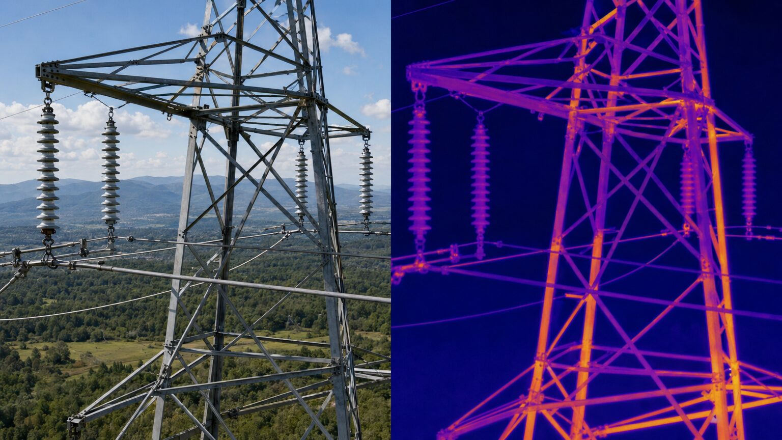
During an inspection, drones are looking for a variety of critical issues. These include vegetation encroachment (trees growing too close to the lines), hot spots caused by failing components, rust and corrosion on towers, damaged insulators, lightning strikes, and even bird nests built in dangerous locations. By identifying these issues early, utility companies can perform targeted maintenance before a failure occurs, saving millions of dollars in outage costs and liability.
How Does a Drone Power Line Inspection Work?
A typical drone power line inspection follows a five-step process: pre-flight planning and airspace authorization, automated or manual flight along the utility corridor, multi-sensor data capture, AI-assisted data processing, and client reporting. This systematic approach ensures all assets are thoroughly documented without putting the pilot or the grid at risk.
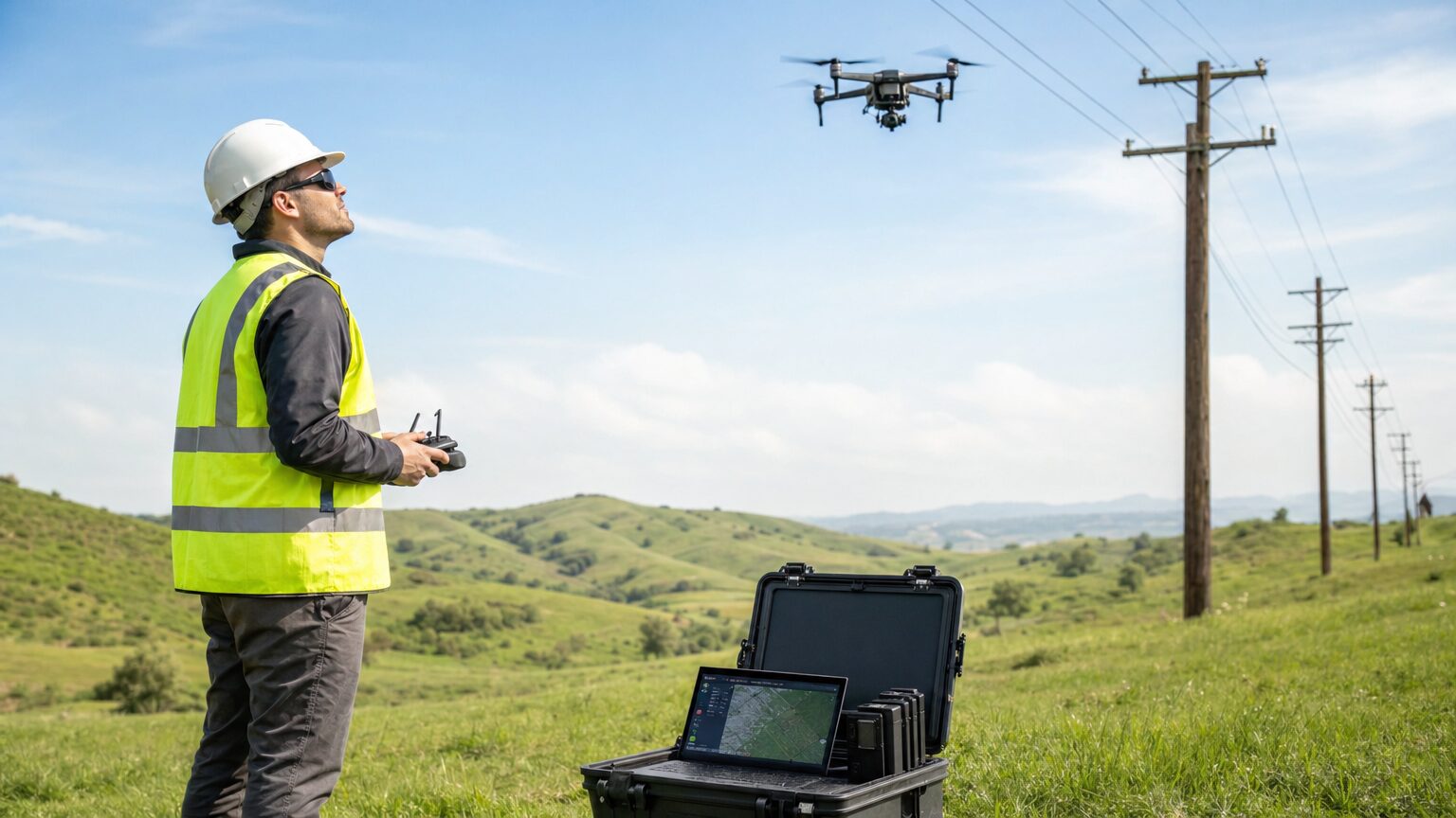
The process begins long before the drone leaves the ground. Pre-flight planning is arguably the most critical step. Pilots must map the intended route, secure necessary airspace authorizations, check for Temporary Flight Restrictions (TFRs), and coordinate closely with the utility company. Because transmission lines often stretch for miles, pilots may need an FAA waiver to fly Beyond Visual Line of Sight (BVLOS), though many inspections are still conducted by moving the launch point to keep the drone within sight.
Once on site, the flight execution phase begins. Depending on the complexity of the environment, the pilot will either fly manually or use automated waypoint missions. The drone must maintain a safe standoff distance from the energized lines to prevent electromagnetic interference (EMI) from disrupting the drone’s compass and navigation systems. During the flight, the data capture phase occurs simultaneously. The drone utilizes its payload—typically a combination of a high-resolution RGB camera and a radiometric thermal camera—to capture detailed imagery of the infrastructure.
After the flight, the pilot moves into data processing and analysis. The raw images and thermal data are uploaded into specialized software platforms like DroneDeploy, Pix4D, or Optelos. These platforms often use artificial intelligence to automatically detect anomalies, stitch images into 3D models, and analyze vegetation proximity. Finally, the pilot generates a comprehensive client report. This deliverable includes defect maps, thermal anomaly reports, and priority maintenance recommendations, giving the utility company exactly what they need to dispatch repair crews efficiently.
What Are the Benefits of Using Drones for Power Line Inspection?
Drones reduce power line inspection costs by 50% to 75% compared to traditional helicopter methods. Furthermore, they drastically improve worker safety by eliminating the need for personnel to climb towers or work near energized lines, while delivering higher-quality, multi-sensor data that detects invisible faults.
When comparing inspection methods, the advantages of drones become immediately apparent. Ground crews are slow, typically covering only 1 to 2 miles per day, and face significant safety risks from climbing and rough terrain. Helicopters are much faster, covering 15 to 30 miles per day, but they are prohibitively expensive and pose a severe risk to the flight crew if an accident occurs. Drones offer the perfect middle ground: they are fast, incredibly safe, and highly cost-effective.
| Inspection Factor | Drone Inspection | Traditional Ground Crew | Helicopter Inspection |
|---|---|---|---|
| Cost per Mile | $200 to $300 | $500 to $1,000 | $1,200 to $1,600 |
| Daily Coverage | 5 to 10 miles | 1 to 2 miles | 15 to 30 miles |
| Safety Risk | Very Low | High (climbing, terrain) | Medium to High (aviation risk) |
| Data Quality | Excellent (Thermal, RGB, LiDAR) | Limited (Visual only) | Good (Visual, Thermal) |
| Outage Required? | No | Sometimes | No |
| Environmental Impact | Zero emissions | Vehicle emissions | High fuel consumption, noise |
Safety is perhaps the most compelling benefit. The utility industry has historically struggled with high injury rates among linemen. By keeping workers firmly on the ground, drones eliminate fall hazards and the risk of electrocution. Additionally, the data quality provided by drones is vastly superior to a lineman’s visual assessment. A drone’s thermal camera can detect a failing splice that is generating excess heat long before it becomes visible to the naked eye or causes a power failure.
What Equipment Do You Need for Drone Power Line Inspections?
Professional drone power line inspections require a commercial-grade drone with Real-Time Kinematic (RTK) positioning, multi-directional obstacle avoidance, and electromagnetic interference (EMI) resistance, paired with a radiometric thermal camera and optionally a LiDAR sensor.
Unlike basic real estate photography, you cannot show up to a transmission tower with a consumer-grade drone. The high-voltage environment surrounding power lines generates significant electromagnetic interference. This EMI can easily scramble a standard drone’s compass, causing it to fly erratically or crash directly into the lines. For this reason, professional power line inspection drones are built with shielded electronics and redundant navigation systems.
The most critical piece of equipment is the payload. You must have a radiometric thermal camera with a minimum resolution of 640×512 pixels. Lower resolution thermal cameras simply do not capture enough detail to accurately diagnose failing components from a safe flying altitude. In addition to thermal imaging, you need a high-resolution RGB camera (20 megapixels or higher) with optical zoom capabilities. This allows the pilot to maintain a safe distance from the lines while capturing close-up images of damaged insulators, rust, and bird nests.
| Drone Model | Best Use Case | Estimated Cost | Key Features for Inspections |
|---|---|---|---|
| DJI Matrice 350 RTK | Enterprise / Heavy Duty | $13,200+ | RTK positioning, 55-min battery, IP45 rating, dual-operator control, 6-directional obstacle avoidance |
| Autel EVO II Dual 640T RTK | Mid-range / Alternative | $9,500 | RTK/PPK capability, 640×512 thermal sensor, 42-min battery, no geofencing |
| DJI Mavic 3 Thermal | Entry / Portable | $4,500+ | Compact, thermal + visual cameras, 45-min battery, omnidirectional sensing |
| Skydio X10 | Autonomous Flight | $10,000+ | Advanced AI obstacle avoidance, 3D Scan capability, designed for complex environments |
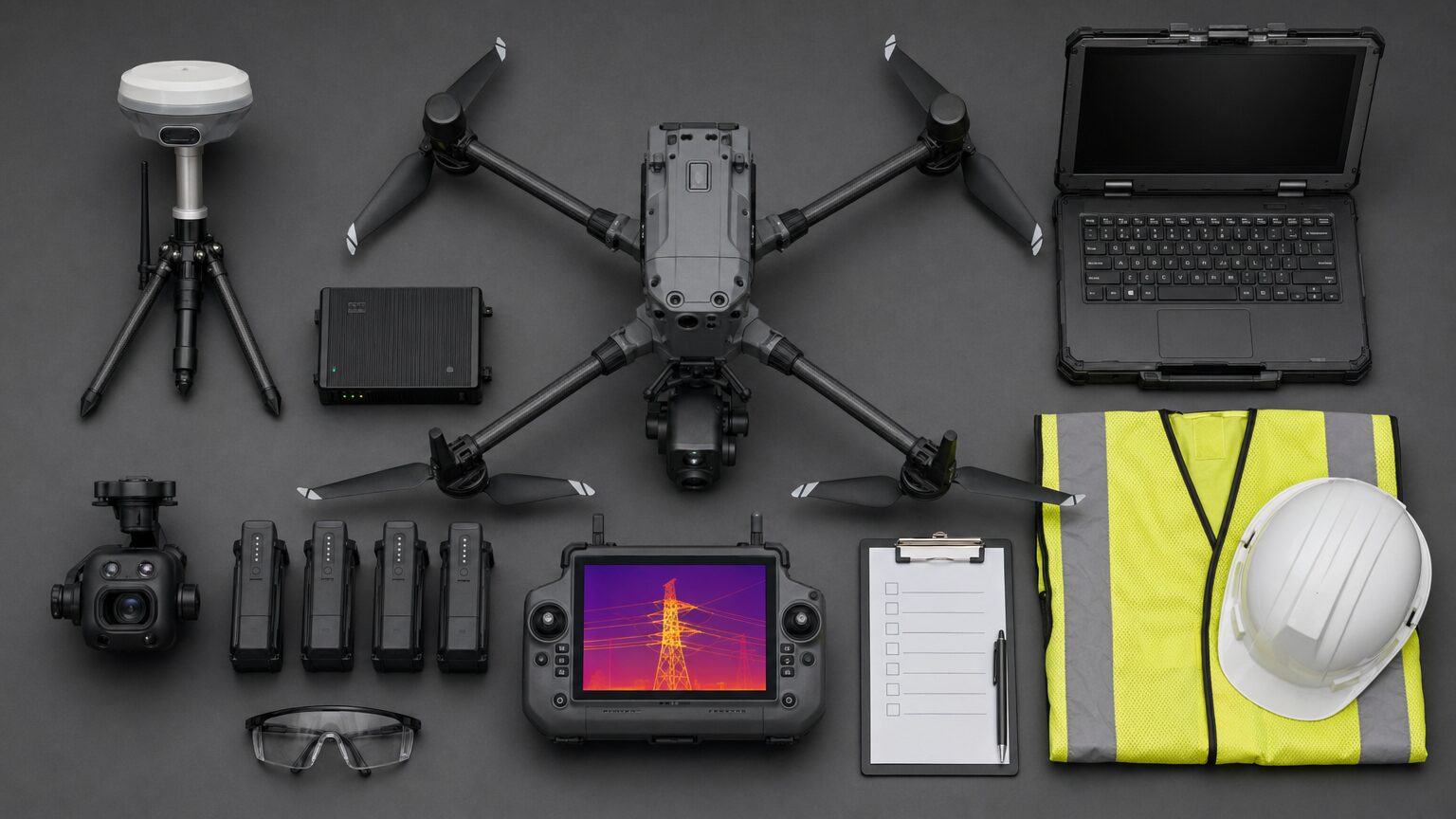
At Drone Launch Academy, we often recommend the DJI Matrice 350 RTK for serious inspection businesses. Its ability to carry multiple payloads simultaneously—such as the Zenmuse H20T (which combines a laser rangefinder, zoom camera, and thermal camera)—makes it the industry standard. For those starting with a smaller budget, the DJI Mavic 3 Thermal is an excellent entry-point, though it lacks the heavy-lift capacity and extreme weather resistance of the Matrice series.
How Much Does Drone Power Line Inspection Cost?
Drone power line inspection services typically cost $200 to $300 per mile for right-of-way inspections and $500 to $2,000 per transmission tower for detailed structural assessments. This represents a massive 50% to 75% savings compared to traditional helicopter inspections, which average $1,200 to $1,600 per mile.
Pricing in the drone inspection industry varies widely based on the scope of work, the geographic location, and the depth of data analysis required. Right-of-way inspections, which focus on identifying vegetation encroachment and obvious asset damage along long corridors, are usually billed by the mile. A utility company might hire a drone pilot to fly a 50-mile stretch of distribution lines, resulting in a $10,000 to $15,000 contract for a few days of flying.
Structural inspections are more intensive and are typically billed per tower or on an hourly basis. A detailed inspection of a single, complex transmission tower might take an hour and cost $500 to $2,000. If you are billing hourly for specialized data collection, rates generally range from $150 to $350 per hour. When you factor in the cost of post-processing the data—stitching 3D models or generating AI-driven anomaly reports—the total project value increases significantly.
While the income potential is high, it’s important to remember that the startup costs are substantial. A professional inspection drone setup, including the aircraft, thermal payloads, extra batteries, RTK base station, and processing software, typically requires an investment of $15,000 to $30,000. However, given the high contract values, many pilots recoup their equipment costs within their first few major utility contracts.
What Training and Certifications Do You Need?
At a minimum, you must hold an FAA Part 107 Remote Pilot Certificate to fly commercially in the United States. For power line inspections, you will also need specialized thermal imaging certification, utility safety training (such as OSHA 10 or 30), and proficiency in automated flight planning software.
The foundation of any commercial drone operation is the Part 107 certificate. If you haven’t obtained yours yet, our comprehensive Part 107 Study Guide is the perfect place to start. However, holding a Part 107 is just the beginning. Utility companies are highly risk-averse and require their contractors to possess specific credentials before allowing them near energized infrastructure.
Thermal imaging certification is crucial. You must understand how to interpret radiometric data, adjust emissivity settings, and distinguish between a true failing component and a harmless reflection. Organizations like the Infrared Training Center (ITC) offer Level I Thermography certifications that are highly respected in the industry. Without this training, you risk delivering inaccurate data that could lead a utility company to dispatch a repair crew unnecessarily—or worse, miss a critical fault that causes a fire.
Finally, you need utility safety training. Operating near high-voltage lines is inherently dangerous, even from the ground. Many utility companies require contractors to hold OSHA 10 or 30 certifications and undergo site-specific safety briefings. You must understand the National Electrical Safety Code (NESC) clearance requirements and know exactly how far your drone must stay from various voltage levels to prevent arcing or EMI interference.
How Do You Get Started in Drone Power Line Inspection?
Getting started in drone power line inspection requires your Part 107 certificate, the right enterprise-grade equipment, specialized training in thermal imaging and utility safety, and a strategy for landing contracts with utility companies or established inspection firms.
The path to becoming a successful power line inspector is not a straight line, but the rewards are significant. Experienced pilots in this niche can earn $60,000 to $120,000+ per year. If you are starting from scratch, your first step is obtaining your Part 107 certificate. Once certified, you must invest in the necessary equipment. While it’s tempting to buy the most expensive drone immediately, many successful pilots start with a mid-range thermal drone like the Mavic 3 Thermal to build their skills before upgrading to a Matrice 350 RTK.
After acquiring your equipment, focus heavily on training. Enroll in a Level I Thermography course and complete an OSHA 10 certification. These credentials are the minimum requirements for most utility contracts. Once trained, you need to build a portfolio. You cannot practice on energized utility lines without permission, so start by practicing your flight skills and thermal data collection on non-energized infrastructure, such as decommissioned poles or large industrial buildings.
The hardest part of entering this niche is landing your first contract. Utility companies are notoriously difficult to break into as a solo operator. A proven strategy is to start by subcontracting for established inspection firms that already hold master service agreements with utilities. These firms often need reliable pilots to execute flights while their internal teams handle the data processing. Networking at industry events like AUVSI Xponential or local utility conferences is also crucial for building the relationships needed to secure direct contracts.
Frequently Asked Questions About Drone Power Line Inspection
How much does a drone power line inspection cost?
Drone power line inspections typically cost between $200 and $300 per mile for right-of-way surveys, and $500 to $2,000 per transmission tower for detailed structural assessments. Hourly rates for specialized drone services range from $150 to $350.
What is the best drone for power line inspection?
The DJI Matrice 350 RTK is widely considered the best drone for power line inspections due to its RTK positioning, heavy payload capacity, and electromagnetic interference resistance. The Autel EVO II Dual 640T RTK is a strong alternative for those seeking non-DJI options.
Do you need a special license to inspect power lines with a drone?
Yes, you must hold an FAA Part 107 Remote Pilot Certificate to fly commercially in the United States. Additionally, most utility companies require thermal imaging certification (Level I Thermography) and OSHA safety training before allowing you on site.
How close can a drone fly to power lines?
The safe distance depends on the voltage of the lines and the drone’s electromagnetic shielding. Generally, drones should maintain a minimum standoff distance of 10 to 30 feet from energized transmission lines to prevent compass interference and arcing, though exact clearances are dictated by utility safety protocols and the National Electrical Safety Code (NESC).
Can drones inspect power lines autonomously?
Yes, many drone power line inspections are conducted using automated waypoint missions. Software platforms allow pilots to pre-program flight paths along utility corridors, ensuring consistent image overlap and precise data collection while the pilot monitors the flight for safety.
How much do drone power line inspectors make?
Experienced drone pilots specializing in power line and utility inspections can earn between $60,000 and $120,000+ per year. Independent contractors often charge $150 to $350 per hour or secure high-value contracts worth $10,000+ for multi-day corridor inspections.
What happens if a drone hits a power line?
If a drone strikes a power line, it will likely be destroyed by the impact or the resulting electrical arc. More importantly, the collision can damage the power line, cause a localized outage, or spark a fire. This is why RTK positioning, obstacle avoidance, and strict standoff distances are mandatory.
How do I get contracts for drone power line inspection?
The most effective way to get contracts is to start by subcontracting for established inspection firms that already have master service agreements with utility companies. Building a strong portfolio, obtaining the necessary safety and thermal certifications, and networking at utility industry conferences are critical steps to securing direct contracts.
Want to turn drone inspections into a real service offer?
Reading about inspection opportunities is a good start, but clients pay for pilots who understand the workflow, safety considerations, deliverables, and business side of the job. Explore Drone Launch Academy’s Drone Workshops to build niche skills, then use Drone to $1K if you want a step-by-step plan for getting clients.
Download the Drone Inspection Starter Checklist
Use this checklist to compare inspection niches, understand required skills, identify client types, and plan your first inspection-service offer. It is designed for pilots evaluating roof, solar, tower, bridge, power line, and wind turbine opportunities.
Need your Part 107 before you start earning with your drone?
If you plan to fly drones for paid work or in support of a business, your next step is earning your FAA Part 107 Remote Pilot Certificate. Drone Launch Academy’s FAA Part 107 Exam Prep Course is built to help you pass the exam on your first try with structured lessons, practice questions, and lifetime access.
Professional drone inspection work is not just about capturing images. It is about understanding what the client needs, planning a safe mission, collecting the right data, and delivering results that help someone make a decision. If this niche sounds like a fit, the next step is to build both your technical skill and your client-acquisition plan. Start with the inspection-related training in Drone Launch Academy’s workshops, then move into Drone to $1K when you are ready to turn the skill into a business.


