Last Updated: May 19, 2026
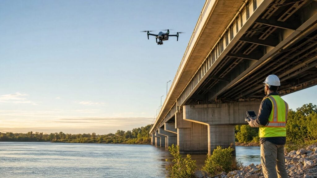
A drone bridge inspection uses a small unmanned aircraft to capture close-up visual, thermal, LiDAR, or photogrammetry data around bridge decks, girders, joints, bearings, piers, and other hard-to-reach areas. Drones don’t replace qualified bridge inspectors, but they can make data collection safer, faster, and less disruptive.
That distinction matters. Bridge inspection is serious infrastructure work, not just “flying around a bridge and taking pictures.” The Federal Highway Administration says periodic and thorough bridge inspections are necessary to maintain safe bridge operation, prevent failures, and help bridge owners make informed investment decisions.1 In 2025, ARTBA reported that 1 in 3 U.S. bridges still needs repair or replacement, with more than 41,600 bridges rated in poor condition based on FHWA National Bridge Inventory data.2
For drone pilots, that creates a real opportunity. A bridge owner, DOT, engineering firm, or inspection company may need better imagery, faster access, or safer documentation. Your job as the pilot is to collect reliable data, follow the rules, and know where your role ends. Unless you’re also a qualified bridge inspector or engineer, you’re supporting the inspection team, not replacing it.
Key Takeaways
Drone bridge inspection is best understood as inspection support through better aerial data. A drone can document areas that are difficult to reach with ladders, lifts, rope access, boats, or under-bridge inspection vehicles, but a qualified professional still interprets structural conditions and makes engineering decisions.
| Key point | What it means in practice |
|---|---|
| Drones improve access | They can capture images of undersides, girders, joints, piers, and other difficult areas from safer positions. |
| Part 107 matters | If you’re paid to fly in the U.S., you generally need to operate under FAA Part 107 and follow registration, Remote ID, airspace, and waiver rules.3 |
| Deliverables drive pricing | Simple photo/video documentation costs less than 3D modeling, thermal, LiDAR, or engineering-ready packages. |
| Pilots need partners | Most new pilots should work with engineering firms, DOT contractors, or inspection companies rather than selling structural conclusions directly. |
| The niche is growing | Aging bridge infrastructure and better drone sensors make bridge inspection a strong commercial drone specialization in 2026. |
What Is a Drone Bridge Inspection?
A drone bridge inspection is a planned flight operation where a drone collects imagery or sensor data from bridge components that may be difficult, expensive, or risky to access manually. The data is then reviewed by the pilot, project team, bridge owner, engineer, or qualified bridge inspection personnel.
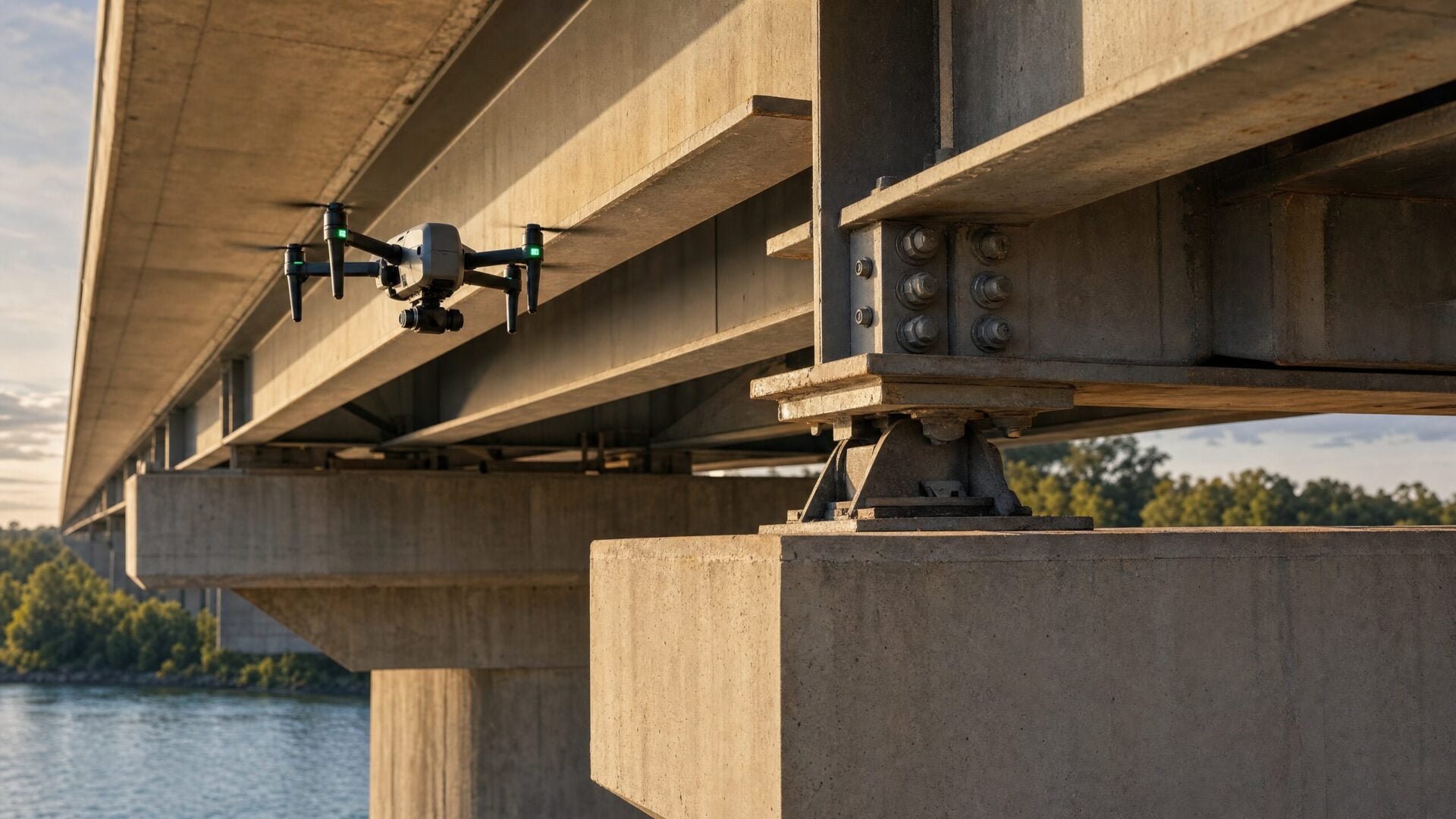
In a typical mission, the drone may capture high-resolution imagery of the bridge deck, expansion joints, bearings, trusses, cables, piers, abutments, drainage areas, corrosion-prone steel, cracked concrete, or underside surfaces. The goal is not just to “get cool footage.” The goal is to collect organized, reviewable data that helps a decision-maker understand condition, prioritize maintenance, or decide where hands-on inspection is needed.
The FHWA’s UAS bridge inspection research describes drones as tools that can assist or augment bridge inspections by collecting sensor data and inspection products.5 That’s the right mindset for this niche.
How Do Drones Improve Traditional Bridge Inspections?
Drones improve bridge inspections by reducing time in hazardous access areas, limiting traffic disruption, collecting repeatable imagery, and helping inspectors see components that might otherwise require lifts, lane closures, rope access, boats, or under-bridge inspection vehicles. They’re most valuable when they make the inspection safer or the data clearer.
Traditional access methods are still essential. A drone can’t scrape rust, hammer-test concrete, measure section loss, or replace hands-on evaluation when regulations or engineering judgment require it. But it can help teams prioritize where to look and collect a visual record that’s easy to share.
| Factor | Traditional inspection | Drone-assisted inspection |
|---|---|---|
| Access | Lifts, rope access, under-bridge trucks, boats, walking access, or traffic control | Drone captures data from safe launch positions where legal and practical |
| Safety | Inspectors may work near traffic, heights, water, or confined spaces | Less direct exposure during early visual assessment and documentation |
| Traffic impact | Lane closures or work zones may be needed | Closures may be reduced or shortened depending on the site and agency requirements |
| Data output | Notes, photos, measurements, and manual observations | High-resolution photos, video, thermal imagery, 3D models, orthomosaics, LiDAR, or annotated media |
| Limitations | Manual access can be slow and expensive | Drone data still requires qualified interpretation and may not replace tactile testing |
This is why bridge drone work is often sold as drone-assisted bridge inspection, not as a standalone engineering service. That language is more accurate, and it helps protect both the pilot and the client.
What Data Can a Bridge Inspection Drone Collect?
Bridge inspection drones can collect high-resolution RGB photos, close-up video, thermal imagery, LiDAR data, photogrammetry image sets, orthomosaics, and 3D models. Specialized drones may also support close-contact or non-destructive testing payloads, but visual inspection remains the most common starting point for most pilots.
The FHWA report lists several useful UAS data products for bridge inspection and construction inspection, including images, orthophotos, orthomosaics, 3D models, surface models, video, infrared sensing, and LiDAR-related outputs.5 In plain English, those outputs help a client see what’s happening on the structure and, in more advanced projects, measure or model it.
For a newer commercial drone pilot, the most realistic deliverables are organized photos, close-up video, and a simple report that identifies what was captured. Advanced providers may deliver 3D models, thermal overlays, RTK-tagged datasets, LiDAR point clouds, or annotated defect maps.
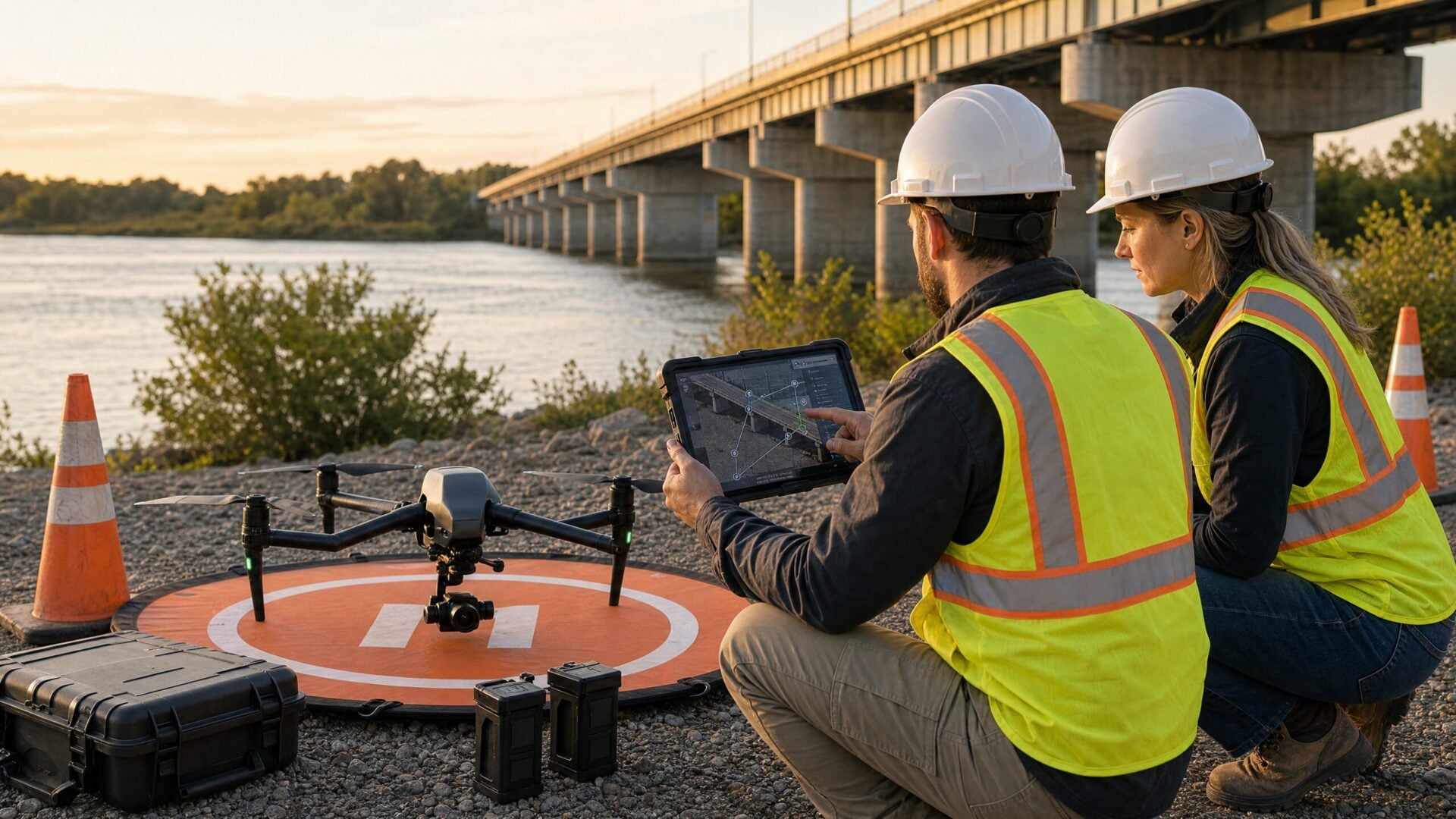
How Does a Drone Bridge Inspection Work Step by Step?
A professional drone bridge inspection usually follows five stages: scope the inspection, plan the flight and safety controls, collect structured data, organize and quality-check the files, and deliver imagery or models to the inspection team. The best results come from planning the deliverable before the drone ever takes off.
First, clarify the scope. Is the client asking for general marketing footage, a pre-bid site overview, visual documentation for an engineer, or a detailed asset inspection package? Those are very different jobs. A pilot who quotes them the same way is likely to lose money or disappoint the client.
Next, plan the operation. That means checking airspace, property access, launch locations, obstacles, traffic, water, wind, GPS reliability, magnetic interference, Remote ID compliance, and whether the flight could involve people, vehicles, night operations, controlled airspace, or visual line-of-sight challenges. The FAA notes that some Part 107 operations require waivers, including certain operations from moving vehicles, beyond visual line of sight, over people, over moving vehicles, or in controlled airspace.3
Then collect the data in a repeatable pattern. Don’t just fly randomly. Work from a shot list or capture plan: deck, underside, joints, bearings, piers, abutments, approaches, drainage, corrosion-prone areas, and any client-specified points of interest. After the flight, review the images before leaving the site. If a critical area is blurry, shadowed, or missing, it’s much easier to refly while you’re still there.
What Equipment Do You Need for Drone Bridge Inspection?
Most bridge inspection work starts with an enterprise-grade drone, a high-resolution camera, obstacle sensing, spare batteries, insurance, and a repeatable data workflow. Advanced jobs may require RTK positioning, thermal cameras, zoom cameras, LiDAR, or specialized payloads for close-structure inspection and infrastructure documentation.
The right drone depends on the bridge, environment, and deliverable. A small bridge may only require a stable aircraft with a good camera. A complex steel bridge over a river, railroad, or busy highway may demand stronger wind resistance, zoom capability, redundant safety features, and closer agency coordination.
Vendor pages ranking in the SERP focus heavily on hardware, and for good reason. Voliro, for example, highlights bridge inspection capabilities such as RGB and thermal cameras, photogrammetry, LiDAR, and specialized non-destructive testing payloads.6 That doesn’t mean every pilot needs a highly specialized system on day one. It means you should match your aircraft and payload to the inspection scope rather than assuming one drone is “best” for all bridges.
For most pilots, the bigger differentiator is not the aircraft. It’s the workflow. Can you capture consistent imagery? Can you keep files organized by bridge component? Can you communicate limitations clearly? Can you deliver a report that an engineer or project manager can actually use? Those skills are what turn drone footage into a professional inspection-support service.
How Much Does a Drone Bridge Inspection Cost?
Drone bridge inspection pricing depends on bridge size, location, access complexity, airspace, traffic-control requirements, deliverables, sensor payload, insurance, travel, and whether the client needs simple imagery or engineering-ready models. Small visual documentation jobs may cost far less than multi-day infrastructure projects with advanced sensors.
A basic visual capture for a small, accessible bridge might be quoted as a half-day or day-rate project. A larger bridge requiring a detailed shot list, multiple batteries, coordination with an agency, and organized deliverables will cost more. If the client needs thermal imaging, LiDAR, 3D reconstruction, traffic-control coordination, specialized insurance, or professional engineering review, the project can move from a simple drone job into a broader inspection contract.
| Scope type | Typical deliverable | Pricing considerations |
|---|---|---|
| Basic visual documentation | Photos and video of visible components | Access, travel, time on site, file organization, and simple reporting |
| Detailed inspection support | Structured image sets, close-ups, annotations, and component folders | Shot list, repeatable capture, more QA time, and client coordination |
| Photogrammetry or 3D model | Image set, model, orthomosaic, or surface model | Software, processing time, ground control or RTK needs, and data accuracy expectations |
| Thermal or LiDAR inspection support | Sensor data and interpreted outputs where qualified | Higher equipment cost, expertise, data processing, and professional review |
| Engineering-supported inspection | Drone data plus qualified inspection or engineering analysis | Partnership scope, liability, reporting standards, and credentialed review |
If you’re a pilot, don’t quote bridge inspection only by flight time. Quote the full job: planning, compliance checks, site time, data capture, backup, processing, reporting, revisions, and risk. If you’re a client, don’t compare bids by price alone. Compare the pilot’s safety process, experience, insurance, deliverables, and ability to work with your inspection team.
What FAA Rules Apply to Drone Bridge Inspections?
If you’re paid to fly a drone for bridge inspection in the United States, you generally need to operate under FAA Part 107, register your drone, comply with Remote ID rules when applicable, stay within operating limits, and obtain airspace authorization or waivers when the mission requires them.
The FAA explains that small drones under 55 pounds may be flown for work or business under Part 107, and remote pilots must learn the rules, pass the Unmanned Aircraft General knowledge test, complete the certification process, and register their drones.3 The FAA also states that registration costs $5 and is valid for three years.3
Remote ID is another important compliance point. The FAA says drones that are required to be registered, including those flown for business, must comply with Remote ID unless operating under an allowed exception.4 That usually means using a Standard Remote ID drone, attaching a Remote ID broadcast module, or operating in a limited FAA-Recognized Identification Area when applicable.
Bridge inspection can also raise practical flight-rule issues. You may be near traffic, people, rail lines, controlled airspace, water, utility corridors, or GPS-denied areas under a structure. You might need the bridge owner’s permission, a site safety plan, airspace authorization, visual observers, traffic-control coordination, or a waiver. When in doubt, slow down and plan the job properly. Infrastructure clients care about professionalism more than speed.
Can Drone Pilots Perform Bridge Inspections Without Being Engineers?
Drone pilots can collect imagery and inspection data for bridge projects, but they should not present themselves as qualified bridge inspectors or engineers unless they hold the proper credentials. The safest business model is to support engineering firms, bridge owners, DOTs, and inspection teams with high-quality aerial data.
This is where newer pilots sometimes get into trouble. A drone pilot can say, “I captured high-resolution imagery of the bridge underside and organized it by component.” A drone pilot who is not an engineer should be very careful about saying, “This bridge is safe,” “this crack is not serious,” or “this girder needs replacement.” Those are engineering judgments.
Position yourself as a data professional. You help clients see the structure more clearly, document conditions, reduce access challenges, and improve communication. If the client needs formal condition ratings, repair recommendations, or compliance reporting, partner with qualified bridge inspection professionals.
How Can You Get Started in Drone Bridge Inspection?
To get started in drone bridge inspection, earn your Part 107 certificate, build close-structure flight skills, learn inspection deliverables, practice controlled data capture, carry appropriate insurance, and partner with engineers or inspection companies before taking on complex bridge work.
A good path is to start with the fundamentals. Learn airspace, weather, operating limitations, crew communication, emergency procedures, and safe decision-making. Drone Launch Academy, founded by David Young, is built around helping pilots develop that regulatory foundation, especially through Part 107 training and commercial drone education.
From there, practice the skill set that inspection clients actually need. Build sample deliverables from safe practice structures, such as public assets where flight is legal and permission is clear, or non-critical private structures where you have owner approval. Organize your images by component, create a sample report, and learn how to explain limitations. If you want to move beyond visual documentation, learn photogrammetry, thermal imaging, RTK workflows, and data processing before selling those services.
You can also strengthen your business foundation with Drone Launch Academy’s guides on drone pilot jobs, how to make money with a drone, insurance for drone business, and the Part 107 study guide.
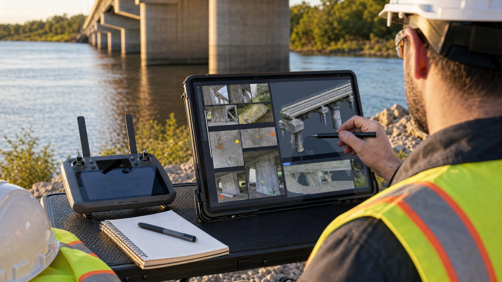
What Should Clients Expect in a Drone Bridge Inspection Report?
A good drone bridge inspection deliverable should be organized, easy to review, and tied to the client’s scope. Depending on the project, it may include geotagged photos, close-up video, annotated images, thermal outputs, 3D models, flight logs, and a summary of areas captured or not captured.
The report does not need to be flashy. It needs to be useful. A project manager should be able to open the folder and understand what section of the bridge each file shows. An engineer should be able to compare images against the shot list. A bridge owner should be able to see whether the drone captured the required areas or whether some locations remained inaccessible due to safety, line-of-sight, lighting, GPS, or permission constraints.
The best reports also include limitations. For example, note if the drone could not safely capture a bearing due to shadow, wind, vegetation, traffic, signal loss risk, or obstruction. That kind of honesty builds trust. It also prevents clients from assuming the drone saw something it didn’t.
Is Drone Bridge Inspection Worth It in 2026?
Drone bridge inspection is worth considering in 2026 because infrastructure owners need better data, safer access methods, and more efficient documentation. For pilots, it can be a valuable niche, but success depends on training, compliance, data quality, and strong partnerships with inspection professionals.
The opportunity is real. The need for bridge repair and replacement remains significant, and drone technology keeps improving. But this is not a shortcut niche. It rewards pilots who are methodical, safety-minded, detail-oriented, and honest about what they can and can’t do.
If you’re a drone pilot, start by becoming excellent at the basics: legal flight, safe operations, sharp imagery, clean file organization, and clear communication. Then build relationships with the people who already understand bridges. That combination — professional drone operations plus qualified inspection expertise — is where drone bridge inspection becomes powerful.
Frequently Asked Questions About Drone Bridge Inspection
Can drones replace bridge inspectors?
No. Drones can support bridge inspectors by collecting imagery and sensor data, but qualified professionals still interpret structural conditions, make engineering judgments, and determine repair or maintenance priorities.
Do you need Part 107 for drone bridge inspection?
Yes, if you’re flying commercially in the United States. The FAA states that drones under 55 pounds can be flown for work or business under Part 107, and pilots must follow the certification, registration, and operating requirements.3
What is the best drone for bridge inspection?
The best drone depends on the bridge, environment, budget, and deliverable. Useful features may include high-resolution imaging, zoom, obstacle sensing, wind stability, RTK, thermal capability, LiDAR compatibility, and reliable low-light performance.
How much does a drone bridge inspection cost?
Costs vary by scope. A simple visual documentation job is very different from a multi-day project requiring traffic control, thermal data, LiDAR, 3D modeling, or engineering review. Pricing should reflect planning, risk, site time, processing, and deliverables.
Are drones allowed to fly under bridges?
Sometimes, but legality and safety depend on the mission. The pilot must consider FAA rules, visual line of sight, Remote ID, airspace, people and vehicles, property permissions, signal reliability, and any requirements from the bridge owner or agency.
What deliverables do clients receive from a drone bridge inspection?
Common deliverables include photos, video, annotated imagery, organized component folders, flight logs, maps, 3D models, thermal imagery, or LiDAR outputs. The right deliverable should be defined before the flight.
How do I start a drone bridge inspection business?
Start with Part 107, safe flight training, insurance, close-structure practice, sample deliverables, and partnerships with engineers or infrastructure inspection companies. Don’t sell engineering conclusions unless you’re qualified to provide them.
Sources
- FHWA: National Bridge Inspection Standards
- ARTBA Bridge Report
- FAA: Certificated Remote Pilots including Commercial Operators
- FAA: Remote Identification of Drones
- FHWA: Collection of Data with UAS for Bridge Inspection and Construction Inspection
- Voliro: The Best Drones for Bridge Inspection
Want to turn drone inspections into a real service offer?
Reading about inspection opportunities is a good start, but clients pay for pilots who understand the workflow, safety considerations, deliverables, and business side of the job. Explore Drone Launch Academy’s Drone Workshops to build niche skills, then use Drone to $1K if you want a step-by-step plan for getting clients.
Download the Drone Inspection Starter Checklist
Use this checklist to compare inspection niches, understand required skills, identify client types, and plan your first inspection-service offer. It is designed for pilots evaluating roof, solar, tower, bridge, power line, and wind turbine opportunities.
Want to turn drone skills into paying clients?
Getting certified is only the first step. If you want a clear roadmap for pricing, outreach, client acquisition, and building a profitable drone business, Drone to $1K walks you through the business-building process step by step.
Professional drone inspection work is not just about capturing images. It is about understanding what the client needs, planning a safe mission, collecting the right data, and delivering results that help someone make a decision. If this niche sounds like a fit, the next step is to build both your technical skill and your client-acquisition plan. Start with the inspection-related training in Drone Launch Academy’s workshops, then move into Drone to $1K when you are ready to turn the skill into a business.


